GEOGRAPHY NOW! IRAN
GEOGRAPHY
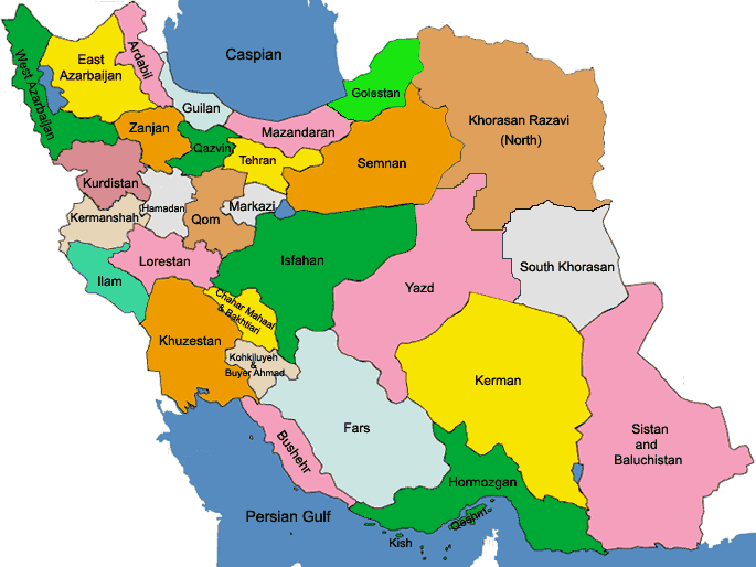
Iran is located in southwest Asia and borders the Gulf of Oman, Persian Gulf, and Caspian Sea. Its mountains have helped to shape both the political and the economic history of the country for several centuries. The mountains enclose several broad basins, or plateaus, on which major agricultural and urban settlements are located. Until the 20th century, when major highways and railroads were constructed through the mountains to connect the population centers, these basins tended to be relatively isolated from one another. Typically, one major town dominated each basin, and there were complex economic relationships between the town and the hundreds of villages that surrounded it. In the higher elevations of the mountains rimming the basins, tribally organized groups practiced transhumance, moving with their herds of sheep and goats between traditionally established summer and winter pastures. There are no major river systems in the country, and historically transportation was by means of caravans that followed routes traversing gaps and passes in the mountains. The mountains also impeded easy access to the Persian Gulf and the Caspian Sea.
With an area of 1,648,000 square kilometres (636,000 sq mi), Iran ranks sixteenth in size among the countries of the world. Iran is about one-fifth the size of the continental United States, or slightly larger than the combined area of thewestern United States (Arizona, California, Oregon, Washington, Nevada, and Idaho).
Iran shares its northern borders with three post-Soviet states: Armenia, Azerbaijan, and Turkmenistan. These borders extend for more than 2,000 kilometres (1,200 mi), including nearly 650 kilometres (400 mi) of water along the southern shore of the Caspian Sea. Iran’s western borders are with Turkey in the north and Iraq in the south, terminating at theShatt al-Arab, which Iranians call the Arvand Rud. The Persian Gulf and Gulf of Oman littorals form the entire 1,770 kilometres (1,100 mi) southern border. To the east lie Afghanistan on the north and Pakistan on the south. Iran’s diagonal distance from Azerbaijan in the northwest to Sistan and Baluchestan Province in the southeast is approximately 2,333 kilometres (1,450 mi).
Iran consists of rugged, mountainous rims surrounding high interior basins. The main mountain chain is the Zagros Mountains, a series of parallel ridges interspersed with plains that bisect the country from northwest to southeast. Many peaks in the Zagros exceed 3,000 metres (9,843 ft) above sea level, and in the south-central region of the country there are at least five peaks that are over 4,000 metres (13,123 ft). As the Zagros continue into southeastern Iran, the average elevation of the peaks declines dramatically to under 1,500 metres (4,921 ft). Rimming the Caspian Sea littoral is another chain of mountains, the narrow but high Alborz Mountains. Volcanic Mount Damavand, 5,610 metres (18,406 ft), located in the center of the Alborz, is not only the country’s highest peak but also the highest mountain on the Eurasian landmass west of the Hindu Kush.
The center of Iran consists of several closed basins that collectively are referred to as the Central Plateau. The average elevation of this plateau is about 900 metres (2,953 ft), but several of the mountains that tower over the plateau exceed 3,000 metres (9,843 ft). The eastern part of the plateau is covered by two salt deserts, the Dasht-e Kavir (Great Salt Desert) and the Dasht-e Lut. Except for some scattered oases, these deserts are uninhabited.
Iran has only two expanses of lowlands: the Khuzestan Plain in the southwest and the Caspian Sea coastal plain in the north. The former is a roughly triangular-shaped extension of the Mesopotamia plain and averages about 160 kilometres (99 mi) in width. It extends for about 120 kilometres (75 mi) inland, barely rising a few meters above sea level, then meets abruptly with the first foothills of the Zagros. Much of the Khuzestan plain is covered with marshes. The Caspian plain is both longer and narrower. It extends for some 640 kilometres (400 mi) along the Caspian shore, but its widest point is less than 50 kilometres (31 mi), while at some places less than 2 kilometres (1.2 mi) separate the shore from the Alborz foothills. The Persian Gulf coast south of Khuzestan and the Gulf of Oman coast have no real plains because the Zagros in these areas come right down to the shore.
There are no major rivers in the country. Of the small rivers and streams, the only one that is navigable is the 830 kilometres (520 mi)-long Karun, which shallow-draft boats can negotiate from Khorramshahr to Ahvaz, a distance of about 180 kilometres (110 mi). Other major rivers include the Kharkeh, spanning 700 kilometres (430 mi) and joining theTigris; and the Zayandeh River, which is 300 kilometres (190 mi) long. Several other permanent rivers and streams also drain into the Persian Gulf, while a number of small rivers that originate in the northwestern Zagros or Alborz drain into the Caspian Sea. On the Central Plateau, numerous rivers—most of which have dry beds for the greater part of the year—form from snow melting in the mountains during the spring and flow through permanent channels, draining eventually into salt lakes that also tend to dry up during the summer months. There is a permanent salt lake, Lake Urmia (the traditional name, also cited as Lake Urmiyeh, to which it has reverted after being called Lake Rezaiyeh underMohammad Reza Shah), in the northwest, whose brine content is too high to support fish or most other forms of aquatic life. There are also several connected salt lakes along the Iran-Afghanistan border in the province of Baluchestan va Sistan.
Area and boundaries
Area:
total: 1,648,000 km2 (636,000 sq mi)
land: 1,636,000 km2 (632,000 sq mi)
water: 12,000 km2 (4,600 sq mi)
Land boundaries:
total: 5,440 kilometres (3,380 mi)
border countries: Afghanistan 936 kilometres (582 mi), Armenia 35 kilometres (22 mi), Azerbaijan-proper 432 kilometres (268 mi), Azerbaijan-Nakhchivan exclave 179 kilometres (111 mi), Iraq 1,458 kilometres (906 mi), Pakistan909 kilometres (565 mi), Turkey 499 kilometres (310 mi), Turkmenistan 992 kilometres (616 mi)
Coastline: 2,440 kilometres (1,520 mi)
note: Iran also borders the Caspian Sea, for 740 kilometres (460 mi)
Maritime claims:
contiguous zone: 24 nmi (44.4 km; 27.6 mi)
continental shelf: natural prolongation
exclusive economic zone: bilateral agreements, or median lines in the Persian Gulf
territorial sea: 12 nmi (22.2 km; 13.8 mi)
Elevation extremes:
lowest point: Caspian Sea -28 metres (−91.9 ft)
highest point: Mount Damavand 5,610 metres (18,410 ft)
HISTORY
FROM PERSIA TO IRAN
THE TWENTY MINUTE TOUR
TE: This DVD was created by the Persian Cultural Center for educational purposes only. Materials used in the making of the DVD have been compiled from secondary sources and may not be used for profit. The contents are based on a good faith understanding of the documented history of the region and do not claim to represent all interpretations of historical events that may be subject to debate.